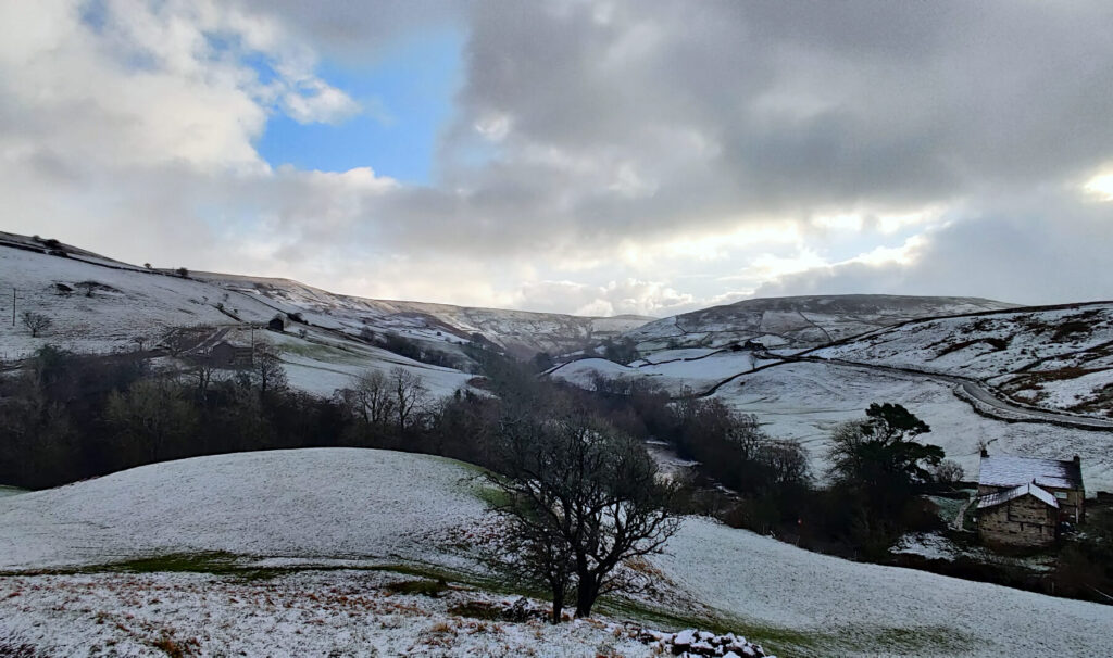
Five Keld waterfalls, an abandoned farmhouse and incredible Yorkshire Dales views – sounds like the perfect day out, right? Well, that’s exactly what’s included in this Yorkshire Dales waterfalls walk!
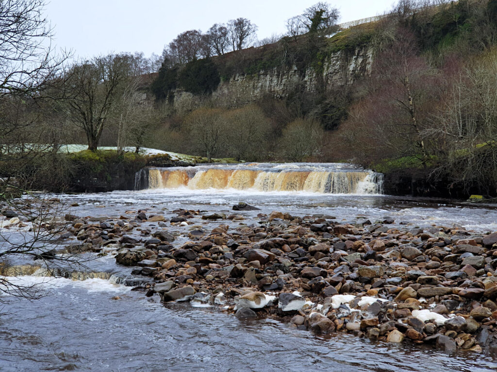
There are plenty of waterfalls in Yorkshire. Popular ones include Cauldron Falls in West Burton, Aysgarth Falls on the River Ure in Leyburn, and Hardraw Force near Hawes.
And, while all of these are beautiful, they’re all fairly isolated. Unless you live in the Yorkshire Dales, you’d be driving quite a way for just one waterfall!
This walk is free and visits five waterfalls around Keld, with the option to branch off to visit an abandoned farmhouse. An optional extra I highly recommend because of the fantastic views from its hillside position!
Below, is all the information you need including maps and photos to guide you through this Keld Waterfalls circular walk.
Hoggarths Leap Waterfall
These long, cascading falls aren’t well-known Yorkshire Dales waterfalls, but they should be. And their location just away from the long-distance trails like the Pennine Way and Coast-to-Coast, means few people visit.
Here’s some more information on this little gem…
Where is Hoggarths Leap Waterfall?
It’s tucked away on the River Swale behind the Park Lodge campsite, just outside Keld in the Yorkshire Dales.
Can you swim at Hoggarths Leap?
With multiple falls along a stretch of the river, there are plenty of places to swim here. Although access is easiest at the top.
What’s the nearest car park to Hoggarths Leap?
The falls are located near Keld Car Park.
Catrake Force
These beautiful, stepped waterfalls are some of the closest to Keld. Located between Wain Wath Force and Kidson Force on the River Swale, they’re easy to visit on foot, with access through Rukin’s campsite.
Want to know more? Here are some quickfire questions…
Where is Catrake Force?
Catrake Force is located a short walk from Keld in the Yorkshire Dales National Park, along the River Swale.
Is Catrake Force on the Pennine Way?
Pretty much, you’ll need to come 0.2 miles off the trail at Keld and take the narrow path at the back of the campsite to reach the waterfalls.
Can you swim at Catrake Force?
Wild swimming is possible here, but the water levels and current vary a lot dependent on recent weather.
What’s the nearest car park to Catrake Force?
The waterfall is located next to Keld Car Park at Rukin’s Campsite.
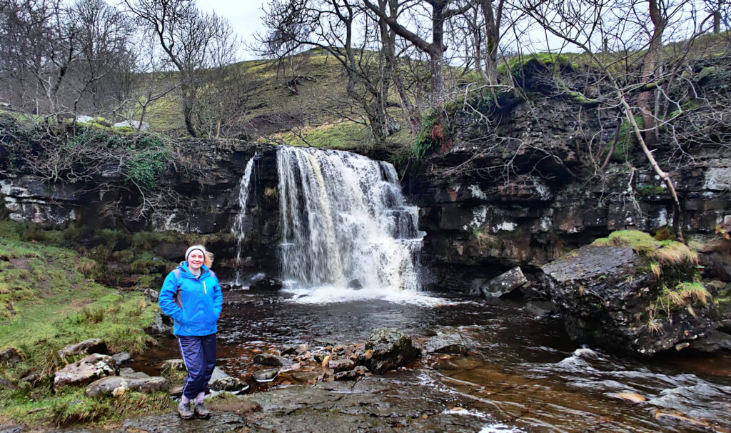
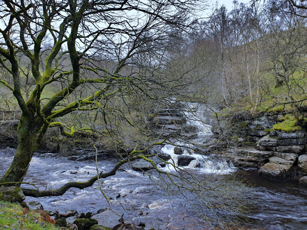
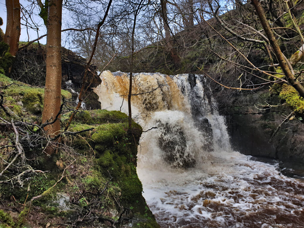
East Gill Force
East Gill Force is a series of two waterfalls.
The upper part is a single-drop waterfall (dropping 4.5 metres), which is the more visible and more easily accessed of the two. In front of the upper East Gill Force is a large, flat rock area allowing you to get fairly close to the waterfall.
While, the lower part, nearest the River Swale, has a staggered drop over 3 metres. The lower part is also harder to get to especially during wet weather. Although, you can get fairly close on the rocks next to it.
Here’s some more information…
The waterfall is a short walk east of Keld, on a smaller stream that flows into the River Swale.
Yes, the Pennine Way Trail will take you past both parts of East Gill Force.
Yes – there’s easier access and more of a pool underneath the upper part of the waterfall.
The lower part is surrounded by steep banks so is far from ideal for swimming. Particularly with the stronger current of the Swale.
Keld Car Park by the campsite is the closest parking to the waterfall, 0.3 miles away.
Currack Force
Currack Force is not the easiest waterfall to get close to. It requires a wet, muddy and adventurous climb down to the best vantage point is necessary – especially in winter!
The spray from the waterfall makes the ground muddy and slippery even on the driest of days, so come prepared. Nevertheless, this single-drop waterfall is well worth the visit.
Where is Currack Force?
The waterfall is northwest of Keld, on Stonesdale Beck that flows into the Swale. The best access to Currack Force is via Stonesdale Lane off the B6270.
Can you swim at Currack Force?
Yes, there’s a good size area close to the waterfalls that’s suitable for swimming.
What’s the nearest car park to Currack Force?
Roadside parking on the B6270 is the closest to Currack Force.
Wain Wath Force
Given its position on the roadside, Wain Wath Force is the most popular and visited spot of these Keld waterfalls.
Although not the tallest or most striking, Wain Wath Force is a wide waterfall with a large plunge pool area. There’s also a picnic area and wheelchair access.
Where is Wain Wath Force?
The waterfall is west of Keld and the most upstream of the falls around. It’s situated right next to the B6270 road, with easy access.
Can you swim at Wain Wath Force?
Yes, the waterfall has a wide pool area although it is quite rocky and not very deep. Additionally, water levels also vary greatly throughout the year.
What’s the nearest car park to Wain Wath Force?
You can park on the roadside right next to Wain Wath Force for free. If it’s busy, try Keld Car Park in the village.
Kidson Force
The most downstream of all the Keld waterfalls, Kidson Force is perhaps the most difficult to access. It’s a bonus sixth waterfall in Keld and isn’t included on the route below due to the harder access.
Access is from the northern side of the River Swale. And the route is steep, muddy and not well signposted.
However, if you do make it, you’ll be treated to a beautiful natural gem and a great wild swimming spot. Plus, this all makes it one of the lesser visited waterfalls in Yorkshire.
Where is Kidson Force?
This waterfall is on the River Swale, near Keld in North Yorkshire. It is sandwiched between the Pennine Way and Upper Swale Trail.
Is Kidson Force on the Pennine Way?
Yes, Kidson Force is right next to the Pennine Way.
But, easier access comes from the other side of the river than what the long-distance trail is on. Luckily, that’s only a couple of hundred metres off the Pennine Way, if you do want to visit.
Can you swim at Kidson Force?
Yes, this waterfall and its large pool area is a great wild swimming spot. However, access is not easy, with the upper part the most accessible.
What’s the nearest car park to Kidson Force?
Nearby parking is available at Keld Car Park in Keld, North Yorkshire.
GRAB MY LIST OF MY FAVOURITE YORKSHIRE WALKS…
➡️ Is your New Year’s resolution to spend more time outdoors or exercise more?
➡️ Want to explore more of beautiful Yorkshire?
➡️ Wishing you knew of more great spots for walks and days out?
Save yourself the hours of research finding hidden gems and local favourites…
with this digital list of 52 beautiful Yorkshire walks full of my favourites from years of exploring.
Discover new places, spend more time in the great outdoors and have fun!
And – as a bonus – it includes 3 free trackers and challenge templates!
> > > GET IT NOW
> OR READ MORE

The Yorkshire Dales Waterfalls Walk Route from Keld
Distance: 4.2 miles/6.7 kilometres
Elevation gain: 140 metres (cumulative)
Difficulty: Easy
Walking time: 2 to 2.5 hours
Start and endpoint: Keld Car Park at Rukin’s Campsite, DL11 6LN
Markers: red, start/endpoint; blue, waterfalls; orange: abandoned farmhouse.
Click the link above to download the file for use in a GPS viewer. This way you’ll be able to track where you are on the route using your phone’s GPS – avoiding accidental detours and providing reassurance for less experienced countryside walkers! Once you’ve downloaded the GPX file above, install a GPX viewer app (Google PlayStore or iPhone App Store) and load the GPX file.
Car parking for the Keld Waterfalls Walk
Parking for this Yorkshire Dales waterfalls walk is available at Keld Car Park (see on a map), next to the campsite. The site operates an honesty box for parking charges: £2 for a few hours and £3 for all day.
Between Easter and the end of September, a small shop and tea room opens at the campsite. Perfect for a pre- or post-walk refreshment.
Hoggarths Leap Waterfall & Catrake Force
- From the car park, walk in the opposite direction to the village following the path towards the river. You’ll pass through the campsite and a gate before first getting a glimpse of the first Yorkshire Dales waterfall on this walk: Hoggarths Leap (blue 1 marker).
- To reach Catrake Force, retrace your steps back through the campsite until you pass another gate. Then, take the narrow riverside path until you see Catrake Waterfall (blue 2 marker).
Keld to East Gill Force
- Retrace your steps again back to the car park. From there, walk back across the village and join the footpath (to the right of the outbuilding) that is signposted as towards the Pennine Way.
- Follow this path until you come to a split. Then, take the left-hand option, heading downhill towards the river.
- You’ll first see the lower part of East Gill Force (blue 3 marker), which is a series of two waterfalls. It might be quite hard to see through the trees, but don’t worry, the best is yet to come.
- Cross the bridge across the River Swale and follow the path until you reach the upper part of East Gill Force. You can’t miss it, it’s almost 5 metres tall!
East Gill Force to the Abandoned Farmhouse and Incredible Viewpoint
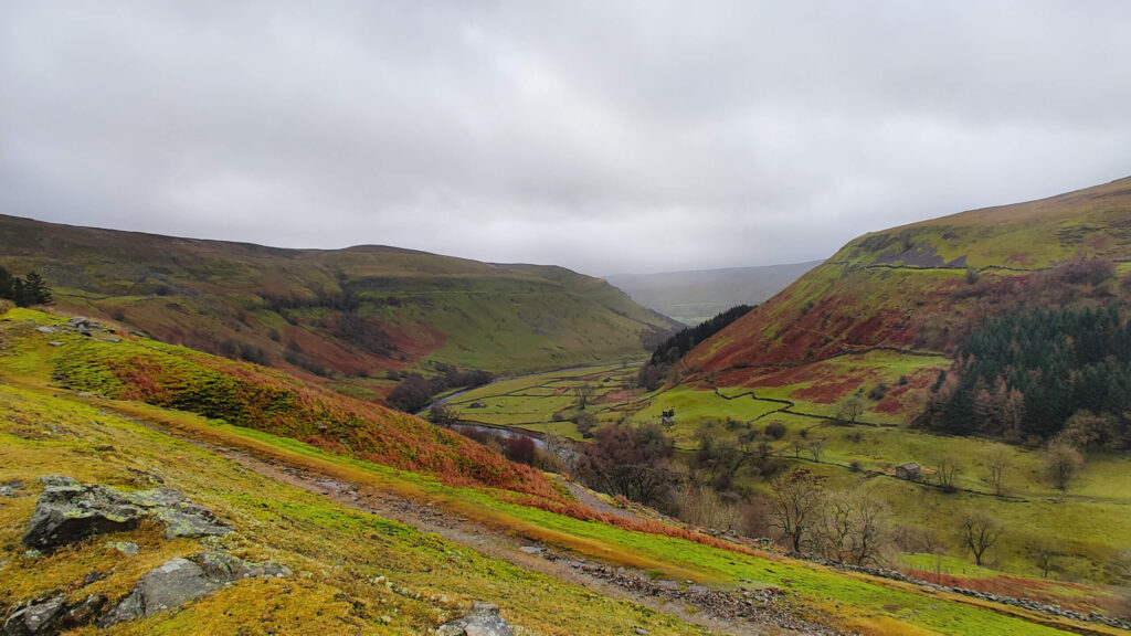
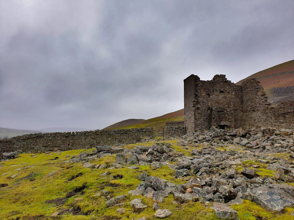
Next up, you’ll venture up to an abandoned farmhouse, which sits at the corner of a valley offering incredible views over the hills. Sound good? Let’s go!
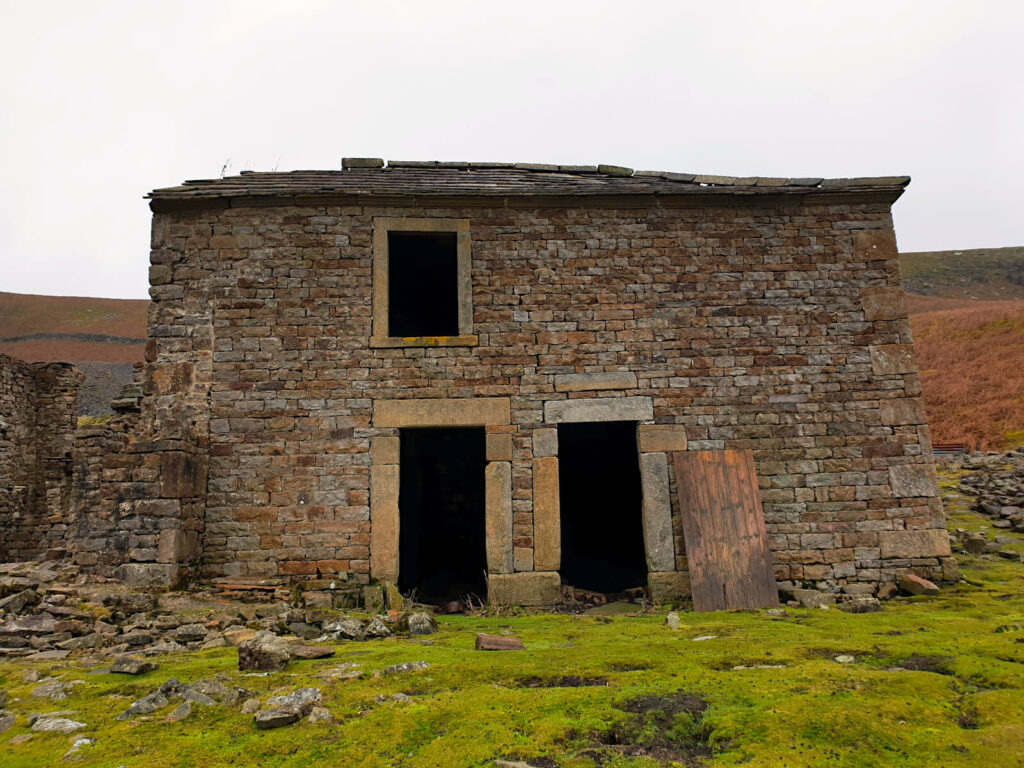
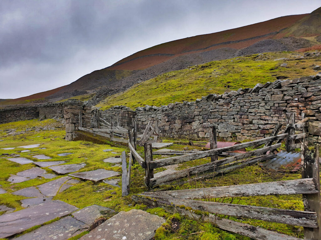
- From East Gill Force, keep following the path over the top of the waterfall and east towards Crackpot Hall (orange marker). This is the name of the now-abandoned farmhouse building that stands in ruins at the top of the valley. Perched on the hillside it offers fantastic views of the surrounding area, even on the rainiest of days, as I can attest to!
- You’ll have reached Crackpot Hall when you see ever-increasing amounts of slate and the remains of a mining car. Head off the path towards the abandoned building above you. Even though it’s off the main path, you’ll be able to follow the trodden ground to these eerie remains.
> > > RELATED POST: For another Yorkshire Dales walk (and some more Yorkshire waterfalls), check out this Malham circular walk route – taking in Malham Cove, Janet’s Foss and Gordale Scar (away from the crowds!)
To Currack Force & Wain Wath Force
- You’ll need to return to East Gill Force by following the same path you arrived on. Once you’ve walked back to and over the top of East Gill Force, take the path as it goes off to the right. It’ll be signposted as the Pennine Way.
- Follow the path for 100 metres or so and then take the track to the left (rather than the path to the right).
- Continue on this track. It’ll take you over the top of Currack Force (blue 4 marker) before you can access it from the field on its far side.
- To get to the next waterfall, head back to the track from Currack Force until it joins a road that snakes downhill and across the River Swale. Turn right at the T-junction, walking along the side of the road until you reach Wain Wath Force (blue 5 marker).
- Enter through the gate on the right-hand side of the road to the viewing spot for the waterfall.
Wain Wath Force to Keld
Return to Keld via the B6270 road running parallel to the River Swale. The distance back to Keld is less than 1 mile and you may need to step onto the grassy banks as cars pass.
If you have any questions or want any more information drop a comment below and I’ll get back to you!
Information correct as of April 2023 but subject to change in future.
Other Yorkshire Walks You Might Be Interested In…
CENTRAL YORKSHIRE DALES: Little Known Malham Walk to Malham Cove, Janet’s Foss & Gordale Scar
CENTRAL YORKSHIRE DALES: Buckden Pike Walk (Circular 5.5-Mile Route)
WEST YORKSHIRE: Lumb Hole Falls (Best Walking Routes & Parking Spots)
SOUTHERN YORKSHIRE DALES: Grimwith Reservoir Walk (Circular Route)
WEST YORKSHIRE: Ilkley Moor Walks: 4 Beautiful Circular Routes
YORKSHIRE DALES: Malham Cove, Yorkshire Dales (Ultimate Visitor’s Guide + Info)
WEST YORKSHIRE: Withens Clough Reservoir (Walks, Parking + More Info)
PIN IT FOR LATER!
Good morning, we’ were priviledged to visit the Dales a few times and to be quite honest, we just love the Dales with all our hearts.! I remember Aysgarth Falls well and would love to visiit again and also tbe fallls mentioned sbove. But we live in South Africa and with everything going on,we don’t know when next we will be able to do so. We visited the UK 5 times and adore the Dales with all our heart. But we live in hope!!
Thank you for this lovely read!
Kind regards,
Susan snd Johan Neethling.
Thanks for your lovely words. The Dales remains one of my favourite places in world seemingly no matter how far and wide I travel and I too can’t wait to return.